|
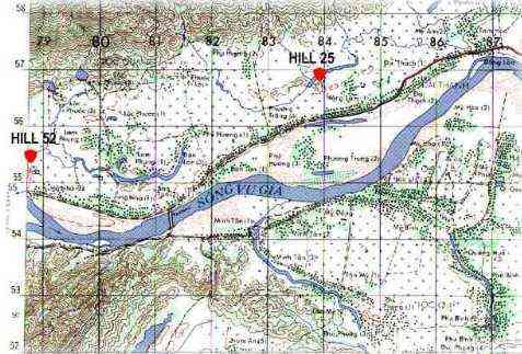
"I will try to give you a little history of the hill. The number
means just 25 meters above sea level. We were the highest ground around for several miles. With the tower we had
a clear view of the valley...
 To the north was Charlie's Ridge. The foothills were about a mile
away from us. The mountains rise up fast to 2,000 - 3,000 feet. We made several squad size patrols up the side
of the mountain but I don't think we ever went over the top. There was a cave up there and at night Charlie would use
a light to send messages to the valley. We would call in artillery and he would just go back into his cave and come
out when it was over. I was inside this cave once, never did see Charlie but he took a parting shot at us when we left
to just let us know he was there. We had alot of successful ambushes of trails coming off that mountain. That
is why Hill 25 was a thorn in their side. We set right in the middle of one of their trail systems. They would
come down from the mountain to cross over into Arizona territory.
Arizona territory was across the Song Vu Gia River. We never crossed
this river unless we went in company size strength. This was the VC backyard. When you crossed that river you
better be ready. It wasn't too safe on this side either. This was another good ambush site. We were
in what you call a fee fire zone. Anything was fair game. This is why the VC wanted us off of Hill 25: they
were losing too many men to us." - Doc Hanmore
Click here for an account of the Attack of Hill 25. (Thanks to the Mike 3/7 Vietnam Association)
Click here for a different account of the assault on Hill 25 (Thanks Vic!)
Click here for photos of the hill the morning after the attack taken by Chuck Traviolia (Thanks Chuck!)
|

